
If you are planning a drive Baja California peninsula, you are likely to be bombarded by comments like “aren’t you scared?” or “is it safe?”. Typically these comments are received from individuals that have never made the drive or perhaps never even visited Baja.
We started the process of purchasing a home in La Paz, BCS, in March of 2021. Knowing that it typically takes up to several months to complete the closing process, we took advantage of that time to thoroughly plan (and replan) our eventual drive from Oregon.
Planning the Baja Drive
Regardless of feelings about social media, it has proven to be a very valuable resource for us relating to all things Baja. Before we even landed on La Paz as our destination, we began following FaceBook groups throughout the Baja Peninsula. This provides a peek into the social climates of the various communities as well as up to date information on weather, road conditions, safety concerns, places to stay, restaurants, etc. Obviously, this is not our only resource (and lots of weeding is required), but it has been very helpful to us.
Tijuana / San Ysidro Border Crossing
We left in late August 2021 with a plan to arrive in La Paz on September 1st. There are many opinions about the various border crossings, with Tijuana (San Ysidro) being the one that is reviewed the most poorly. We were dropping off our rented trailer of belongings with a mover (Michael Pilgrim, MexPat Movers) in the San Diego area, so we opted for the Tijuana/San Ysidro crossing. Fortunately, our mover gave us specific directions on how to navigate this busy border.

It was fairly early on a Monday morning. We needed to go into the immigration office to process our residency. We had also itemized the belongings that we were bringing with us (we had our pickup with a canopy and were quite loaded) and translated them to Spanish. We paid the minimal duty after a quick inspection and were on our way.
Travelling with Dogs
We have three dogs that made the move with us. Annual rabies vaccines are required in Mexico, and in addition to those records, we had Health Certificates. Health Certificates are not required, but our US veterinarian provided them. None of these papers were reviewed at the border. We did have our dogs in crates for the crossing and then harness restrained during the entire drive.

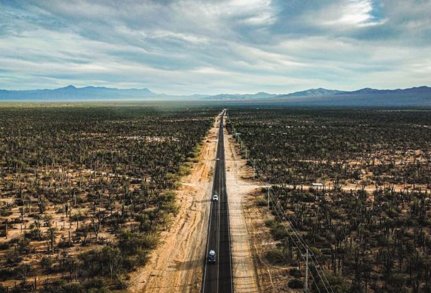
Driving Baja California Tips
A few general and oft-repeated notes about driving Baja:
- Mexican auto insurance is required. It is inexpensive and easy to purchase.
- The roads are narrow, twisty, often do not have shoulders, and often have limited visibility.
- Fill up your gas tank whenever you can, as there are long stretches without services. Also, take advantage of those stops to use the restroom, as there are no “rest stops” in all of Baja.
- You will not have cell phone service much of the drive. We downloaded google maps and also have a Baja Atlas (we did not need either as highways are well marked).
- Do not drive at night. This is not due to crime but to open-range livestock and lack of visibility.
- If a semi-truck in front of you has its left turn signal on, they are inviting you to pass.
- Mexican drivers often use their flashers for a variety of reasons, slow down, and use caution.
Mexico Police Bribes?
In your research, you will likely find many comments about visitors being asked for bribes when they are pulled over by police or at military checkpoints. This has not been our experience so far.

At military checkpoints, we always remove our sunglasses and greet the officers in a friendly manner. If we are asked to get out of the car, we take our personal belongings with us. We found that having our customs declaration ready for their review is helpful.
Driving Baja California in Hurricane Season
Hurricane season is July – November and should definitely be a factor while planning a road trip. There was a hurricane forecasted during our first road trip, but it didn’t hit the Baja Peninsula. We did get to experience a tropical storm (Olaf) the week after our arrival, and much of Baja (La Paz was thankfully spared) was impacted in early September 2022 by Hurricane Kay. We have found weather reports to be very accurate and constantly updated. Again, social media is beneficial for this type of communication.
Avoiding Tijuana
As we left the border crossing, our mover told us to stay to the right to avoid going into Tijuana. This proved to be great guidance, as we bypassed the crazy busy city. Tijuana is not one of the many Baja communities we are interested in exploring, so we were happy to be on our way quickly and smoothly.
There didn’t seem to be much of a distinction between the Tijuana and Rosarito areas. I have heard that many ExPats enjoy living in Rosarito due to the proximity (a reasonable drive) to the United States. We lost sight of the Pacific Ocean as we continued on Hwy 1 through the stunning Ensenada area – so green and lush! A return visit to experience the many beautiful wineries is definitely on our list! Travelers do complain about this section of the drive, as you may be stuck behind farming equipment.
Drive Baja California – Highway 3
We have heard that taking Highway 3 from Ensenada across to Highway 5 may be a time saver. As this was our first time driving, we stayed on Highway 3 and had reservations about spending the night in Catavina. We did not follow the advice of getting fuel every time we could and missed filling up in San Quintin. Sure enough, there wasn’t a gas station open in Catavina. Fortunately, a man was selling gas alongside the road, so we were able to breathe easy the next morning, knowing we had enough to get to the next station.

The cacti in this area are unlike any other in Baja. They remind me of the illustrations in the Lorax by Dr Seuss. The boulder fields in the Catavina area are breathtaking in their beauty and seem to be “placed” for maximum effect. We arrived at the Mision Santa Maria in the mid-afternoon and appeared to be one of just a few guests.

When we left the next morning, the parking lot was full, so this is a popular spot for travelers. We enjoyed a wonderful dinner in the restaurant onsite. Accommodations were clean, and the grounds were pleasant. This is a spot I would like to visit again. There are caves in the area to explore, and it is a great place to unplug (literally, as there is not much in the way of WiFi).
We did find gas between Catavina and Guerrero Negro. Guerrero Negro is on the Pacific, where Baja Norte transitions to Baja California Sur and clock settings move ahead an hour. Many travelers use Guerrero Negro as their midway point on their drive of the peninsula. It is also a whale watching destination from December through April, with February and March being the prime times. For me, this could be a spot to spend the night and fuel up, but I haven’t found a reason to visit for recreation (yet).
Santa Rosalia
The next town we passed through was Santa Rosalia on the Sea of Cortez. I would like to explore a bit there in the future, as the approach and departure through the town do not provide enough of a feel for what this community has to offer.
Mulege
The town of Mulege has a more green, tropical vibe – very pretty and definitely worth a longer visit that also incorporates the many area beaches. These are among the most beautiful beaches we have seen in Baja: Playa Santispac, Playa Escondida, Playa El Burro, Playa El Coyote and then on to Playa Ventura, Playa El Requeson, and Playa Armenta.
Loreto
We planned for Loreto to be our second overnight stop and had reservations at Hotel Angra (hotelangra.com). This is a small hotel with secure gated parking. The owner directed us to a great spot for dinner within walking distance (Domingos). We didn’t spend any time on the Malecon, but we will definitely do that on a return trip.
Arriving at La Paz
It was a relatively quick drive to El Centenario/La Paz the following morning, driving through the quaint towns of Ciudad Insurgentes and Ciudad Constitucion on the way. All in all a stress-free and beautiful drive down the peninsula. We went through three checkpoints on the first day (border to Catavina) and were waved through each time. On the second day, we went through a few more checkpoints and had brief conversations and one quick inspection.

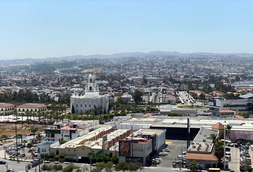
La Paz
Our home base is La Paz – so obviously, we love it! The capital of Baja California Sur is a large city and has great services. There is much to see and do in La Paz – the Malecon and the gorgeous beaches, to name a few. We often take day trips to Todos Santos (one hour), La Ventana (45 minutes), Los Barriles (one and a half hours), El Triunfo (45 minutes), and even Los Cabos (two hours). These spots are each unique and worthy of a visit or a stay.

The Return Leg
Our next Baja road trip was back to Oregon in August of 2022 to pick up the remainder of our belongings. We drove our Mexican plated vehicle (our Mexican policy covers liability in the US). We left early in the morning and experienced another beautiful, uneventful drive. We did take another route, taking advantage of Highway 5 and driving by another stretch of breathtaking beaches.
San Felipe
Prior to accessing Highway 5, we passed the turn for Bahia de Los Angeles, a spot that I definitely want to visit soon. After passing many beachfront “Campos”, we arrived in San Felipe in the late afternoon. We were experiencing some vehicle mechanical issues and were able to find a shop that made the repair as we waited.
San Felipe is a great town! I would like to spend some time there. It does seem more Americanized, which is not surprising given its proximity to the border. We were meeting someone in San Diego the next day, so we decided to push through and cross the border that evening. The road between San Felipe and Mexicali is fairly straight and smooth.
We crossed at Mexicali West, and it was somewhat confusing – by then, it was dark, and the border was very busy. We had about a 45-minute wait and then crossed into Calexico for the night. We used google maps for the crossing. It seemed way more complicated than it needed to be but ultimately got us where we needed to be.

On our return back to Baja from the US, we spent the night in Rancho Mirage and crossed at the Mexicali East border. We went through the declaration area and once again had our items listed and translated to Spanish. This was a Wednesday morning, the border was not busy, and the staff was friendly and efficient. We once again took Highway 5 through San Felipe, retracing our route to spend the night in San Ignacio. This is a friendly scenic community with a charming town square. We stayed at Hotel La Huerta and had a fantastic dinner and breakfast at the restaurant onsite. From there, the next morning, we headed home to La Paz.
Conclusion
As you can see – there are many routes and sightseeing options when you drive Baja California Peninsula. Obviously, our trips so far have been “fast and furious” as my husband likes to drive and is very destination oriented (ie, not spontaneous). Most people making the trip like to break it up into four to five hours of driving daily. The layout of Baja provides endless opportunities to explore and plan a fabulous road trip. Spending single nights in some spots and multiple nights in others could make for a relaxing and diverse vacation. Many of our acquaintances have camp trailers and enjoy spending time (days!) on the beaches as they travel up and down Baja.
My wife and I have been driving from Tacoma, Washington to San Diego, CA (where we used to live) to Guerrero Negro on the east side of Baja then to Loreto where we have a timeshare. The road has been washed away in some areas. There are signs cautioning drivers to slow down before reaching these areas. These road damages where caused by the hurricane that went through couple of weeks ago. It is very safe and people have been very nice everywhere we stayed along the way. This is our second drive through Baja from San Diego. Do not drive after dark and watch out for animals crossing the road especially near towns. There are many gas stations Restuarant and hotels along the way. All the best….
Thanks for updating us on the current conditions and tips.
Hi! My father passed earlier this year and November/December we will be driving his Jeep (US registration) back from San Jose Del Cabo to Tacoma where we live. We were aware of the hurricanes and road damage: I’m trying to get a feel for what “washed away” means. For instance, we drove along the coast from La Paz to SJD and some areas were more like driving forest service roads around here — bumpy dirt — which we are totally comfortable with. Are the Baja wash-outs similar? Is it just some temporary off-roading? Thanks for any additional info!
Hello, Sorry for your loss. November and/or December should be a decent time to make the drive throughout Baja. The adverse conditions you may experience may likely be the mountain passes in the US that time of year. We are so impressed how quickly the roads are made passable after storms come through Baja. We have had friends make the drive towing trailers within a week of a storm going through. If you are on Facebook, a few of the groups provide daily updates on road conditions, specifically Talk Baja, Talk Baja Road Conditions and All things Baja. A recent post did say that there are a lot of road repairs happening. Make sure the vehicle has Mexican insurance for your trip – Discover Baja and Baja Bound are good sources of both insurance and road information.
Dude it’s a Jeep!
You continued on hwy 1, not hwy 3.
Thanks for the update.
I have visited La Paz regularly for fishing over the last 30 years and wonder why you would post such a beautiful, myth-busting article about the Baja city; it is supposed to be a secret.
La Paz is a beautiful city. I will have to go fishing next time we’re there.
It’s the California peninsula, not Baja. Baja California is the state geopolitical name, not the geographical name.
Firstly – thank you for the great info. Question – on your return leg, did you drive from La Paz to San Felipe in one day? Google says that is a 16-hour drive. Is there a place you recommend to stay between the two locations? Thanks!
Thank you! Yes, on our return leg, we did cross the border and stayed in Calexico. Not sure I would recommend that – it depends on your driving tolerance. We packed food and used the restroom when we stopped for gas. This was August before major storms, so the roads were in good condition. We left La Paz at 5:30 am and arrived in San Felipe at 4:00 pm (time falls back an hour when you cross from Baja California South to Baja Norte). We actually had a minor mechanical issue that we had repaired so we were in San Felipe until after 6:00 pm. Having never crossed there before (Mexicali West), we relied on google maps. There were many twists and turns, but it did lead us to the correct spot. We checked into the Best Western in Calexico by 9:30 pm or so.
Most people opt to spend the night in San Ignacio (Huerta Inn was nice), Guerro Negro, or San Felipe.
hu, we’re wanting to drive from Mexicali to Cabo in January (no hurry).We’ve been told to rent a jeep if possible. we’re having a hard time finding a place to rent one. Also any advise on not being upsold on the insurance. our Pergresive policy will cover the comprehensive end of insurance.
thanks Kelly
I’ve read that the worst part is crossing back into the USA, especially if you get into the wrong lane. If you enter the lane for expedited entry without proper credentials you can be fined five thousand bucks!
We drove down a few weeks ago and are now in Todos Santos. Great drive down. We stopped in San Felipe, and mulege. Easy.
Hope the USA can be a little less intimidating to returning US citizens. They can be real Aholes.